
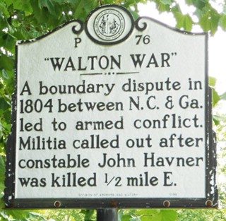
A war is a legacy event; when a war was held within the confines of a modest-sized county, it seems the type of event that would be ingrained in the heritage of the town. However, a war was fought in Transylvania County which has largely slipped the collective memory of the area’s residents to such a degree that reports on the dates of the battles differ by as much as six years. Due to the surrounding historical events which are broadly agreed upon between sources, this writer has accepted the earlier date as correct.
The Walton War took place in December 1804. The only known memorial in Transylvania County is a Highway Historic Marker near Hap Simpson Park. While it technically fits the accepted definition of a war—”an armed conflict between the forces of sovereign governments”—it is not widely recollected in the same way our society generally commemorates wars. Perhaps this is due to the way in which the conflict began.
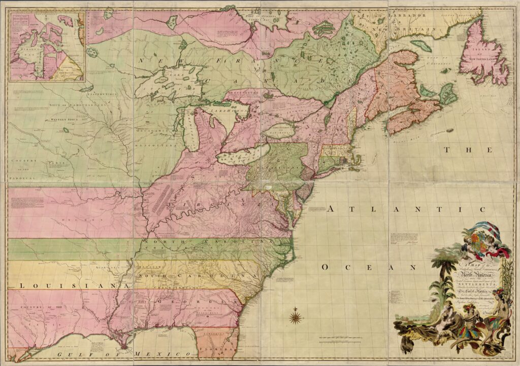
It was a slow start over many decades and took shape in a dry, clerical fashion, with a heavy emphasis on confusion over geography and boundaries. Testament to this is the fact that the war between North Carolina and Georgia was fought over territory not remotely close to the border of modern-day Georgia.
The boundary-related confusion dates as far back as the founding days of our nation and the establishment of the border in the early 1700s within what had been the Carolina Proprietary colony into the individual Royal Carolina colonies North and South. Per King George II, the boundary began 30 miles south of the point the Cape Fear River met the ocean, then struck northwest until it was supposed to join and follow the 35th parallel westward. However, in 1737 a commission tasked with marking this boundary erroneously located the 35th parallel approximately 12 miles shy of its actual position, and there promptly stopped their survey instead of continuing west as they were meant to. Their report to the Provincial Council cited “extraordinary fatigue running the said line most of that [through] desert and uninhabited woods” and insufficient compensation to continue the line beyond joining the 35th parallel. This incorrect position influenced numerous future surveys and boundary lines and eventually led to war.
Such flawed surveys during this period can be explained by the surveyors’ method and tools of choice. In this instance, records mention only a magnetic compass and Gunter’s chain. A magnetic compass locates magnetic north rather than geographic or true north. The angle of difference between magnetic and true north is known as magnetic declination—a phenomenon known in the 1700s—which can vary many degrees by both time and location due to Earth’s constantly shifting magnetic field. Thus, as a compass is useful for rough longitudinal findings, it is not particularly useful for latitude, which is the point of contention here.
A Gunter’s chain is also a tool of limited merit. Used to measure distance and maintain bearing, it is only as good as the user’s ability to travel in a perfectly straight line across the terrain in question, which meant difficult terrain led to faulty lines. Therefore, neither tool purportedly used by the 1737 party was suited to longitudinal readings, which seems an oversight for a border survey.
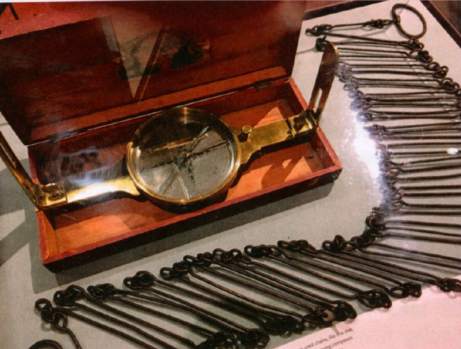
To improve accuracy, many colonial surveyors had been known to include the services of an astronomer in their party, or if they themselves were trained appropriately, would make use of either an astrolabe or quadrant (the precursors of the sextant). While originally for seafaring navigation, their efficacy made them popular for land navigation as well. Both tools were used to measure the angle and altitude of celestial bodies from the horizon in order to calculate latitude. As none of these methods were noted as included in the 1737 survey party, a sole reliance on magnetic wayfinding on a large scale would leave them miles from their intended destination.
Although these tools and techniques were available, no efforts were made to improve the accuracy of these findings either in 1737 or later, when the boundary survey was resumed and continued west in 1764. Even when it was finally acknowledged in 1772 that the 35th parallel had been missed, the new team simply struck farther north to compensate before they continued west, rather than attempt to accurately locate the elusive line of latitude.
Another factor creating the jumble of boundaries lay with the rapidly diminishing Cherokee lands. Settlers repeatedly encroached on Cherokee territory, while coordinated militia attacks in 1776—launched by North and South Carolina, Virginia and Georgia—targeted Cherokee towns. These attacks were spurred by fears that the Cherokee would side with the British in the Revolutionary War. As a result the borders of their lands were in near-constant flux. The purpose of many of the surveys which referenced the incorrectly identified 35th parallel was to identify and confirm those borders between settlers and Cherokee.
In the late 1780s, the northern states further complicated the boundary question when they became concerned that the larger southern states would gain an uneven amount of political control over the direction of the newly-minted nation, due to Congressional representation being proportional to population size. To rectify this, the northern states insisted on a condition to ratify the U.S. Constitution: that the larger southern states must cede their westerly lands to the federal government for the creation of future states.
Due to the mistaken location of the 35th parallel and unfamiliarity with the difficult and mountainous terrain of the area, in 1787 South Carolina ceded land to the federal government to which it had no claim. Later in 1798 Cherokee Territory changed yet again under the Treaty of Tellico when the Cherokee ceded more land to the U.S government. This land cession overlapped with and added territory to that surrendered by South Carolina in 1787.
These ceded lands then took on a very unusual life. The resulting chunk came to be known as the “Orphan Strip” as, rather than being hotly contested by various entities wishing to claim it as their own, it was contested by various entities refusing any claim to it. This concludes part I of this Picturing the Past series, concerning the logistics which created the rogue strip of land over which the Walton War was fought. The next part in the series will cover the extenuating circumstances leading to the Walton War.
Photos and information for this column are provided by the Rowell Bosse North Carolina Room, Transylvania County Library. This article was written by Katie Silver, Venue Coordinator and Local History Assistant. Sources available upon request.