
This final installment on the Orphan Strip & The Walton War will address the immediate causes, military engagements, and the near-decade of contention that followed the Walton War.
Though the earliest white settlers had moved onto the land which would become Walton County without express permission, many of its later tenants arrived with grants in their name issued by the surrounding states. Many of these inhabitants either felt they owed their loyalty to their granting state or they believed that if another state was given authority over the area in which they lived, their grant might be revoked.
Particularly, anyone whose land had not been granted by Georgia had reason to fear exactly that. As a result of North and South Carolina’s long-standing border disputes, days prior to the act establishing Walton County they had adopted legislation which stated that any land transfers or grants in the area which later proved to be in the opposing state would be honored by that state. This sort of pre-survey agreement was common practice at the time due to the uncertain nature of state lines. Nonetheless, when Georgia’s governor was approached with the same agreement, he refused, claiming Georgia had made no grants in the area and argued that such an agreement would only benefit North Carolina grantees, leaving their own—who their claim asserted didn’t exist—to be displaced.
The federal act which created Walton County had expressly stated that county government could not commence operation until a boundary line between North Carolina and Georgia was run. But as Georgia refused to cooperate with any border survey until NC removed the land grant provision, the two states were at an impasse and eventually Georgia moved forward with governing the county despite the survey mandate.
While the states were largely indifferent about the outcome of the Walton County dispute, residents of the area had very strong opinions. And so it was that when Daniel Sturges plagiarized Kilpatrick’s survey as the line he was intended to find and his report made public, even those residents who had long supported South Carolina as their parent state but had acquiesced to control by North Carolina officials now refused to cooperate with those officers, and unrest began to grow.
It spread like wildfire as this was also the year that Georgia began taxing its newly acquired citizens, and since much of Walton County was within the bounds of what was then Buncombe County, North Carolina did as well. Understandably the citizenry of the area objected vehemently to double taxation. A Buncombe County report details that those residents who supported Georgia’s claim to the land would “raise with force and arms and threaten our officials”. There were several petitions by residents of Walton County to the federal government seeking resolution of the matter, where their concerns were ultimately ignored.
Thus in December of 1804 events came to a head when the residents of this Georgia county—including several who were known to be officials—began a series of three attacks upon North Carolina settlers of the same county over the course of two weeks.
The first of these took place on December 3rd, wherein Robert Orr was assaulted at his home and held captive there for approximately an hour. Evidence suggests that the perpetrators’ purpose in holding Orr was to force a pledge from him to cease interfering with Walton County operations. The second attack on William Raxter occurred on December 13th at his home by Cathey’s Creek, near current-day Selica. The list of offenders is nearly the same as the first attack, as is the description of the attack itself. The third attack took place on December 14th, wherein 21 men attacked Buncombe County constable John Havner (or Hafner) on his property near where the McGaha Branch joins the French Broad River. In the fighting, Samuel McAdams of Georgia struck Havner in the head with the butt of his rifle, killing him.
As a result, on December 17th, the commander Buncombe County’s militia directed Major James Brittain to raise as many of their militia as necessary to show the rioters that North Carolina had “law sufficient to suppress unruly citizens”. On December 19th Major Brittain and over 60 men mobilized and proceeded to arrest the most notorious among the pro-Georgia rioters (specifically the county officials) who were taken to the nearest town with a prison, Morganton. All ten appear to have escaped before seeing trial, though they claimed their only crime had been refusing to accept North Carolina’s authority over Walton County. Accounts of the battle are unclear but say between one and 14 perished in the fighting.
A few years later, commissioners from both states wrote a joint convention allowing that the troubles in the area had been a result of settlers’ confusion over which was the sovereign state and recommended amnesty for all but capital crimes, meaning only Samuel McAdams who killed Constable Havner should face charges. Following the events of December 1804 however, Samuel McAdams seemingly vanished without a trace. While reports vary, they agree that unrest and violence continued in Walton for several years, including “riots, affrays, assaults, batteries, woundings and imprisonments,” though no further fighting with militias can be officially confirmed.
Not until 1805-06 was it finally clarified that both states thought the 35th parallel to be their natural boundary. North Carolina’s insistence on the land grant provision had been due to Georgia assuming the Kilpatrick line as the boundary, which NC knew had been intended to be well north of the line of latitude. With this settled they were finally willing to relent, allowing the matter of grants to be tabled until after the survey.
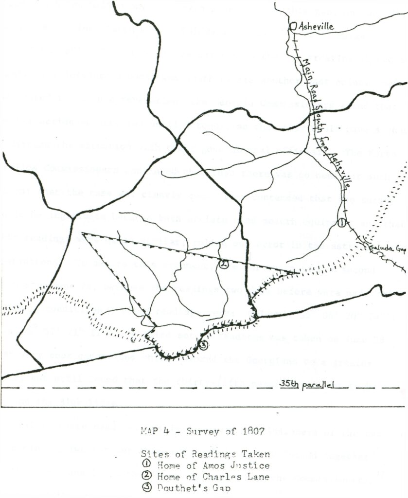
Representatives and astronomers from each state went to work, taking measurements at three points miles apart to attempt to finally find the 35th parallel. Though none of their calculations were matched exactly, all confirmed these points to be miles above the 35th parallel. The final, most southern point was measured by all present on three occasions over five days. The results remained unchanged. Georgia’s representatives were “astonished and mortified” upon discovering that the “northern boundary [of Walton] was south of its southernmost point.”
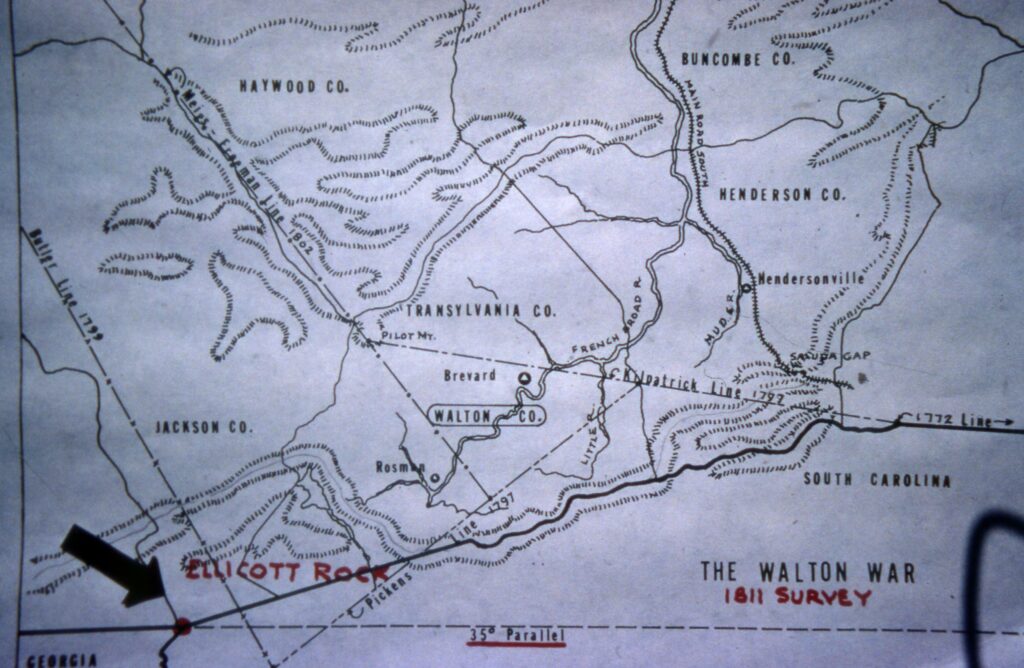
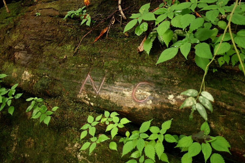
Despite initiating the commission and agreeing with its findings, Georgia persisted in governing the county and in 1811 hired renowned surveyor and astronomer Andrew Ellicott with the purpose of resolving the matter in their favor. However, his work confirmed the 1807 findings, and he located the tri-state corner along the Chattooga River, inscribing a rock which came to be named for him, Ellicott Rock, with the letters N for North Carolina and G for Georgia. Georgia finally relinquished their claims on the county that year. Historical evidence suggests that they never paid Ellicott for his work.
In 1971 Georgia legislature attempted to revive the Walton County dispute, stating they had a legitimate claim to the area, and the NC general assembly apparently “in a jocular mood” authorized the governor to mobilize the National Guard to “protect, defend and hold inviolate [the border]…against the spurious claims of Georgia.” Despite this curious bid, the border question appears well and truly resolved. This article concludes the Picturing the Past series on The Orphan Strip and the Walton War.
Photos and information for this column are provided by the Rowell Bosse North Carolina Room, Transylvania County Library. This article was written by Katie Silver, Venue Coordinator and Local History Assistant. Sources available upon request.